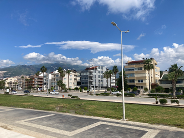
Iskenderun
The ancient commercial city between port and mountains
İskenderun, one of the largest districts in Hatay, is situated in southeastern Türkiye between the Mediterranean Sea and the Amanos Mountains. Its strategic coastal location and the nearby İskenderun Bay have greatly influenced the city’s historical, economic, and cultural development.

ISKENDERUN
Mediterranean Sea

City Context
Total Population :
559.405 Hab.
Surface Area :
5.403 km2.
Household Size :
3,3 Hab/House.
Population by Gender

MAN (50,4%)
WOMAN (49,6%)
Proporcional Population by Age Range Groups Distribution

0 - 14 years (21%)
15 - 64 years (67%)
15 - 64 years (11%)
10%
20%
30%
40%
50%
60%
70%
80%
Economic Values:
Historic Trace:
• Trade
• Agriculture
• Mining (iron and steel)
• Clean energy
• Logistics
• Faith tourism
• Olive oil and laurel soap
• Gastro tourism
• The first church of Christianity.
• One of the places of the Christian cross in the world.
• Traces of Roman architecture.
• The oldest mosque in Turkey: Habib-i Neccar Mosque.
•Important personalities Cemil Meriç,
Sabahattin Hüsnü, Yalçın Küçük and many
others writer, poet and Mehmet Aksoy (sculptor).
Social Infraestructure:
Natural Values:
• 10 Library
• 1 Theater
• 1 University
• 2 Cinema
• 1 Museum
Education:
• Southeastern Taurus.
• Beginning (Amanos Mountain, Musa Mountain, El Mansuriye Mountain, Kızıldağ, Bozdağ, Amik Plain, Dörtyol Erzin Plain, Arsuz Plain, Samandağ Plain).
• Asi River (94km in Hatay, 380km in total).
• Karasu (122km), Afrin Stream (197 km).
• Mediterranean coast length 175, 6km.
• Mustafa Kemal University.

Strategic location:
A Mediterranean City
İskenderun is a strategically important port city on Turkey's southeastern Mediterranean coast, serving as a vital gateway for trade between Europe, Asia, and the Middle East. Its location allows for efficient maritime shipping routes, enhancing its role in global commerce.
As a key Mediterranean port, İskenderun provides direct access to the sea, essential for commercial shipping and naval operations. The city also acts as a logistical hub for both commercial and military needs, reinforcing its significance in regional trade.
Additionally, İskenderun features a well-developed transportation infrastructure, including road and rail connections to major Turkish cities and neighboring countries, which fosters trade and supports industrial growth in manufacturing and shipping.
İskenderun Bay features three main ports:
-
Yumurtalık Port specializes in handling bulk cargo, particularly agricultural products and industrial goods. Its strategic location ensures efficient access to domestic and international shipping routes.
-
ISDEMIR Port is a small harbor designed for the steelworks within Isdemir's territory, playing a vital role in supporting local industries. The establishment of the İskenderun Iron and Steel Works in the 1970s significantly boosted the city’s economy.
-
İskenderun Port is a key center for industrial activity, enabling the import and export of diverse goods and facilitating international trade.
ISDEMIR PORT
ISKENDERUN PORT
Seismic Condition of the Region


On February 6, 2023, Iskenderun was struck by a powerful 7.8-magnitude earthquake from Kahramanmaraş, accompanied by more than 1,000 aftershocks. This disaster brought catastrophic damage, displacing thousands of families and resulting in a dire humanitarian crisis that demands urgent attention and action.

İskenderun is situated within the East Anatolian Fault zone, making it part of a seismically active region. This geographic feature renders the area prone to earthquakes, and the city has a history of experiencing significant seismic events.
The most recent earthquake occurred on February 6, 2023, when a series of powerful earthquakes struck the region with magnitudes of 7.7 and 7.6. Centered in Kahramanmaraş province, these earthquakes resulted in tens of thousands of deaths, injuries, and extensive damage across multiple provinces, including Hatay and İskenderun.
The February 2023 earthquake was Turkey’s deadliest in the past century and ranks as the 10th deadliest earthquake globally in the last hundred years. It affected over 400,000 buildings in Hatay, with half of them being either demolished or severely damaged. Additionally, the earthquake created geological problems along the coast of İskenderun, including widespread liquefaction and subsidence, which led to flooding, landslides, and rockfalls, all of which have had critical impacts on infrastructure.
NOTE:
Additional materials and the city file in DWG format will be provided to students internally once their competition registration is confirmed.


